
NJPACT & NJ REAL Explained: What New Jersey’s New Flood Rules Mean for Coastal Development
- SJ Hauck Construction
- Dec 8, 2025
- 7 min read

If you work in land development, engineering, construction, or real estate in New Jersey, you have likely been hearing more about NJPACT, the NJ REAL rules, and a proposed +4 foot increase to the 100-year floodplain.
Typical questions right now include:
Is New Jersey really raising the 100-year floodplain by four feet?
How will this affect barrier island development and flood-prone communities?
This article is intended as a factual, neutral explainer for industry professionals. It outlines what the rules are designed to do, the core technical change, and why they are generating strong reactions both for and against.
What Is NJPACT?
NJPACT stands for New Jersey Protecting Against Climate Threats. It is a regulatory initiative directed by Executive Order 100 (2020), which instructs the New Jersey Department of Environmental Protection (NJDEP) to update environmental regulations to account for climate change impacts such as sea-level rise, increased flooding, and more frequent extreme weather.
NJPACT has two main components:
Resilient Environments and Landscapes (REAL) – focused on land use, flooding, and resilience.
Climate Pollutant Reduction – focused on greenhouse gas and air pollutant reductions.
In practice, when industry stakeholders ask “What is NJPACT?”, they are usually referring to the REAL rulemaking, because that is what directly affects flood hazard, coastal development, stormwater, and permitting.
What Is NJ REAL?
REAL stands for Resilient Environments and Landscapes. It is NJDEP’s proposed package of rule amendments under NJPACT that would modernize several existing regulatory programs, including:
Flood Hazard Area Control Act rules
Coastal Zone Management rules
Freshwater Wetlands rules
Stormwater Management rules
The purpose is to move from regulations based primarily on historic floods to a framework that incorporates projected sea-level rise and changing flood patterns out to roughly the end of the century.
NJ REAL – Stated Goals
NJDEP and supporting materials describe the REAL rules as intended to:
Replace outdated flood mapping systems that do not fully account for projected climate conditions over the next 100 years.
Reduce the financial burden on taxpayers by making new development and redevelopment in extremely flood-prone areas more difficult, thereby limiting future disaster-relief and recovery costs.
Strengthen insurance stability and FEMA compliance by protecting eligibility for disaster aid, flood insurance, and Community Rating System (CRS) discounts.
Control dangerous redevelopment practices, especially where properties repeatedly flood and are rebuilt to similar pre-event standards.
Align New Jersey with climate-resilient development policies such as U.S. Army Corps flood-resilience standards, insurance-industry risk modeling, and coastal zone management policies in order to avoid future large-scale disaster bailouts.
These goals are central to how NJDEP frames REAL: not as a new program, but as a modernization of existing land-use and flood standards in light of updated climate and flood data.
Status and Timeline
As of late 2025:
The original REAL proposal was published in 2024 as part of NJPACT.
Following significant public and stakeholder feedback, NJDEP issued a Notice of Substantial Change (NOSC) on July 21, 2025, revising several key elements, including the elevation standard.
Multiple law firms, engineering groups, and municipal organizations report that final adoption is anticipated in January 2026, after consideration of the latest round of comments.
The final rule text and any additional revisions will determine exact implementation details and transition timelines.
Core Technical Change: Raising the 100-Year Floodplain by +4 Feet
At the technical core of the REAL proposal is a change to how New Jersey defines the regulatory 100-year floodplain (also referred to as the 1-percent annual-chance flood elevation):
Current: The regulatory flood elevation in many areas is effectively equal to FEMA’s Base Flood Elevation (BFE). About 16% of New Jersey currently lies within a FEMA-mapped floodplain.
Proposed under REAL: The regulatory design standard in coastal and tidal areas would be based on FEMA BFE + 4 feet, reflecting projected sea-level rise and associated storm surge over the coming decades. This effectively raises the 100-year floodplain by 4 feet for regulatory purposes and expands the mapped area considered within the state’s climate-adjusted flood hazard area.
For barrier islands and low-lying coastal communities—where ground elevations are often only a few feet above current sea level—this shift can mean that a significantly larger share of parcels fall within a regulated flood hazard area, and that new construction and substantial improvements must meet higher elevation or floodproofing requirements.
Other Key Elements of REAL
In addition to the +4-foot adjustment to the 100-year floodplain, REAL proposes several structural changes relevant to engineers, planners, and builders:
A new mapped zone for areas projected to experience permanent or daily tidal inundation within the planning horizon.
For residential buildings and critical facilities in these areas, the rules would introduce additional constraints, including stricter elevation and floodproofing requirements and more limited permitting for certain types of development.
Expanded Coastal Flood Hazard Area
By basing the regulatory flood on BFE + 4 feet, the tidal and coastal flood hazard area jurisdiction would extend further inland compared to current mapping.
Updated Stormwater Management Requirements
REAL strengthens stormwater expectations in areas where existing infrastructure does not adequately manage runoff, with the intent to reduce both localized flooding and pollutant loading.
The rule package emphasizes and enforces the importance of proper stormwater control during redevelopment in flood-prone communities.
Nature-Based Solutions and Habitat Considerations
The rules encourage nature-based resilience strategies such as restored wetlands and living shorelines, while attempting to balance habitat conservation with support for renewable energy and critical infrastructure.
Process and Alignment Changes
Alignment with FEMA’s NFIP standards and clearer tracking of permits from authorization through construction completion are intended to improve predictability for regulated parties and municipalities.
Why NJDEP Is Pursuing REAL: Risk and Resilience Rationale
The rationale cited by NJDEP and supporting organizations rests on several lines of analysis:
A large portion of New Jersey’s coastline is already at high or very high risk of erosion and flooding, with projections indicating that risk will increase over the coming decades.
Scientific studies and state-commissioned work with Rutgers and others project multiple feet of sea-level rise by 2100, along with more intense precipitation events.
Existing regulatory standards are largely based on historic flood behavior, which may understate exposure to future flood conditions for structures built today with expected lifespans of 50–75 years or more.
From this perspective, adjusting the 100-year floodplain upward by +4 feet and expanding regulated coastal areas is seen as:
Reducing life-safety risk,
Lowering long-term public disaster-recovery costs, and
Providing a consistent, forward-looking design target for the industry.
Why REAL Is Generating Division: Key Arguments Against and For
REAL has prompted a strong response from coastal municipalities, counties, and business groups, particularly in Cape May, Atlantic, Ocean, and Monmouth Counties, alongside support from environmental and planning organizations.
Concerns Raised by Opponents
Common themes among resolutions, public statements, and analyses critical of the NJPACT / REAL rules include:
Economic and Development Impacts
Higher elevation and floodproofing requirements increase construction and redevelopment costs for both public and private projects.
Expanded flood hazard areas may affect property values, complicate financing, and make certain small-scale or infill projects less feasible.
Municipalities are concerned about long-term impacts on ratables and local tax bases, particularly on barrier islands that rely heavily on shore development.
Scope of Regulated Area
With many barrier islands only a few feet above sea level, some local officials argue that applying BFE + 4 feet effectively places nearly all properties in certain communities within a highly regulated flood zone, narrowing redevelopment options.
Choice of Sea-Level Rise Scenarios
Some stakeholders contend that using upper-end sea-level projections to define statewide regulatory standards goes beyond FEMA guidance and may be more conservative than necessary, especially for communities with limited resources.
Governance and Authority
County resolutions and business associations question whether significant land-use changes of this scale should be made primarily through executive-order-driven rulemaking, rather than new legislation. Several entities, including Cape May County, have authorized or initiated legal challenges on this basis.
Implementation and Equity
Opponents raise concerns about the feasibility of bringing older housing stock and infrastructure up to standards over time, and about disproportionate impacts on lower-income homeowners and small businesses if financing and state support do not keep pace.
Arguments Advanced by Supporters
Environmental organizations, regional planners, and some municipal leaders and practitioners present a different emphasis:
They argue that existing rules no longer reflect current or projected flood risk, leading to repeated damage and costly rebuild cycles.
REAL is framed as primarily affecting new development and substantial improvements, not as a retroactive mandate for all existing structures.
Supporters describe the rules as a proactive approach that can reduce future disaster costs, support more predictable insurance markets, and avoid “surprise” non-compliance as federal standards evolve.
The emphasis on nature-based solutions and improved stormwater management is seen as an opportunity to address both flooding and water-quality challenges in urban and suburban communities.
In short, the divide is less about whether climate resilience is important and more about how much risk to regulate for, how quickly to change standards, and how the costs and responsibilities are distributed.
Practical Takeaways for Industry Professionals
Regardless of where individual firms or municipalities stand on NJPACT and REAL, the direction of travel for New Jersey’s flood-related rules is clear: higher design elevations, broader mapped flood areas, and more explicit consideration of future conditions.
For developers, engineers, and builders, key implications include:
Site Feasibility: Early due diligence should include checking whether a parcel falls within proposed BFE + 4 ft zones or the Inundation Risk Zone, using NJDEP mapping tools and local analyses.
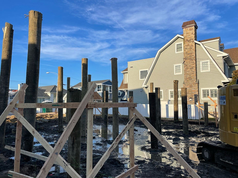
Foundation and Structural Strategy: Elevated design, open foundations, and piling systems are likely to be used more frequently for both residential and commercial shoreline projects.
Permitting Strategy: Transition rules and any grandfathering provisions (for applications deemed complete within a set timeframe after effective date) will be important for projects already in the pipeline.
Stormwater and Site Design: Redevelopment in flood-prone communities will face stronger stormwater control expectations, encouraging integrated green infrastructure and nature-based solutions.
Client Communication: Design teams will need clear, fact-based explanations for owners, lenders, and community partners about what “BFE + 4 feet” means in practice for costs, design, and long-term risk.
Still have questions? Contact SJHauckConstruction to get the full scope and insight on what's to come from one of the Northeast's premier flood mitigation experts.


Comments